Special Custom Maps and Services

Enable unforgettable experiences within complex venues and locations with our specialized interactive digital mapping solutions.

From vibrant event venues to sprawling holiday parks, we create detailed interactive maps that go beyond standard navigation. Our custom solutions help venue managers and event organizers enhance visitor experiences, streamline operations, and create lasting impressions.

Where conventional maps end, GeoJunxion’s expertise begins. Whether you need detailed harbor navigation, high-definition venue mapping, or last-mile precision, we turn complex locations into clear, actionable maps.

What we offer

Last Mile Maps

Creating bespoke digital maps for last mile navigation within outdoor and indoor venues.

The Last Mile Maps solution utilizes cutting-edge technology to ensure compatibility and functionality with any device and operating system.

Example of Digital maps integrated with interactive 3D Virtual Tours

CUSTOMIZED AND INTERACTIVE MAPS

Discover your unique interactive digital maps which highlight only the services for your customers and/or use-case.

RESPONSIVE AND COMPATIBLE ACROSS ALL DEVICES

Your users will experience seamless experience with the Last Mile Maps, regardless of your device or operating system. The responsive layout ensures perfect usability on smartphones, tablets and desktops.

WEB APP

Thanks to a SMART SaaS solution, all maps, interactive icons, and connected services function perfectly on any device and with any operating system.

ROUTING YOUR GPS

With routing and wayfinding features your users can find the best route suited to their mobility needs to reach any location.

EMBED IN WEBSITE

Embedding the Last Mile Map on your website has never been easier, thanks to the included iFrame codes with the service provision.

GDPR COMPLIANT

All Last Mile Map solutions and technology are 100% compliant with GDPR directives.

The innovative SaaS solution for modern Marinas.

It enhances marina management with real-time docking guidance and interactive maps, seamlessly integrating as an add-on to existing IT systems for safe, stress-free navigation without app downloads or logins.

The innovative solution for modern Marinas. DockingMap delivers essential advantages for Marinas, including streamlined communication to boaters and visitors, improved staff efficiency, reduced Skipper stress, enhanced docking safety, and increased sustainability – all contributing to a modern and seamless user experience. DockingMap is not a management software but a SaaS add-on to complement your existing tools, without any IT integration costs.

ENHANCE MARINA COMMUNICATION

DockingMap is an easy-to-use SaaS tool to communicate crucial information to Skippers: berth locations, dimensions, and manoeuvring spaces in two clicks.

INCREASE STAFF EFFICIENCY

The system minimizes staff workload by automating the sharing of precise and complete berth information independently from staff members’ skill and experience, allowing Marina staff to focus on other tasks.

REDUCE SKIPPER STRESS ON DOCKING

DockingMap reduces Skipper’s stress by providing clear docking instructions and details for manoeuvring spaces, particularly during their first arrival. This makes docking smoother and safer.

COMPLETE THE MARINA WEBSITE INFO

The platform includes a georeferenced and interactive digital map, navigable via GPS on smartphones and tablets, enhancing the user experience and promoting Marina services on its website.

MINIMIZE RISKS DURING MOORING

DockingMap provides clear docking instructions, helping Skippers reduce the risk of accidents or errors during mooring, thereby protecting both people and boats.

GROW THE MARINA’S SUSTAINABILITY

DockingMap enhances sustainability by streamlining communication, cutting fuel consumption, reducing manoeuvring impacts, and eliminating paper use.

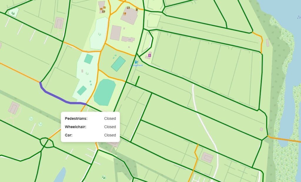
Route Network Editor is a powerful GeoJunxion’s proprietary solution for creating, modifying, and editing routes. It allows users to dynamically manage road networks, including opening and closing roads to enable or disable specific point-to-point routes. This tool provides precise control over route planning and management for various applications, with the possibility to easily embed it in third-party applications and solutions. Route Network Editor is also an optional add-on of GeoJunxion’s Last Mile Maps.

Control your routes with precision using Route Network Editor, a powerful solution for dynamic road network management.

Get Started Now!

Our experts are always happy to help. Complete the form or contact us to connect with our team and start your journey with GeoJunxion today!