Improve your solutions with GeoJunxion’s comprehensive suite of geospatial data and services.
Our enterprise-grade products power leading navigation apps, GIS platforms, and logistics solutions worldwide.
From precise address data to advanced mapping APIs, we deliver the essential building blocks for smart routing, accurate ETAs, GIS studies and sustainable transport solutions. Our standardized formats and databases help businesses create innovative applications that drive real-world results.
What we offer
Addresses
Enhance your maps and create richer user experiences with help from our Innovation Lab.
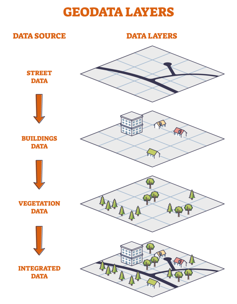
GeoJunxions Address Database is a digital database, optimized for address search, address entry and route planning. The data is stored consistently on different levels throughout the database and contains address information – including cities, street names, house numbers, postcodes and geographical coordinate (lat/long).
The data includes:
Essential address elements
House numbers
Geographical coordinates (latitude /longitude or x,y coordinated)
GeoJunxion’s Address Database offer both proprietary address databases and normalized and harmonized Open-Source Database.
Digital Maps
As an evolution of the former AND’s Global Road Database, GeoJunxion Digital Maps dataset is a worldwide vector-based digital road map, optimized for route planning, time-distance calculations and optimization studies. The data is stored consistently on different levels throughout the database, enabling the selection of appropriate data sets that meet your application requirements. Country, province, urban area boundaries and major lakes and rivers are included worldwide for geographic reference.
The data includes:
Essential route planning features
Urban area boundaries
Major lakes, rivers and railways
Postal codes
Points of Interest (airports, rest areas, etc.)
Our reputation was built on digital maps and they remain at the heart of our business.
Coverage down to the neighborhood level in more than 55 countries in Europe, the American continent and Asia Central and Eastern Europe covers 129 cities on street level, Central and South America covers 25 cities on street level and North Africa covers 5 cities on street level. Suitable for worldwide map visualization, route optimization and geographic analysis Maintained and expanded in consultation with our partners, ensuring accurate and reliable data at all times, in a price-affordable configuration.
Admin Boundaries
Customers around the world trust in our expertise, robust quality control processes and effective production methods.
GeoJunxion offers Administrative Boundaries for your website or solutions to add information or visualization to your website or solutions. Administrative boundaries are the geographic boundaries of countries, states, counties, cities, and other administrative subdivisions. They are used to define geographic areas for administrative purposes, such as voting districts, socio-economic analysis, regional planning, and other administrative functions. The GeoJunxion Administrative Boundaries are accurate representations of the administrative levels within a country. These can be part of the solution for: geo-locating, turn-by-turn navigation, routing, geofencing, local search, GIS analysis, geotagging and track & trace.
USE CASES
Geo-referenced BUA polygons can be applied to various use cases (just a few examples): To pre-determine speed limits or other driving restrictions To plan and monitor the fleets’ distribution activities and strategically locate their logistics hubs To analyse and determine the value of properties For pre and post analysis of users’ driving activities and behaviour To plan and manage resources to serve customers To monitor and plan activities on their territories distinguishing BUAs from other official administrative boundaries To plan and execute marketing activities where there is higher return of investment To enhanced map viewing and layering, weather applications, generic location positioning and many more.
COVERAGE
Map: World
Geocoding
TYPICAL USE CASES
Geocoding and reverse geocoding are part of many use cases across various industry verticals Geocoding can be part of: turn-by-turn navigation, routing, geofencing, local search, GIS analysis, geotagging and track & trace. In most of the cases, the geocoder will be used to get numerical coordinates referring to a specific address, in order to perform geospatial analysis.
GEOCODER API
The Geocoder API has two options, the regular address to GPS coordinates function and the reverse look-up whereby GPS coordinates are translated to an address
KEY FEATURES
Forward Geocoding Reverse Geocoding Free form and Structured address search House number ranges, interpolated, extrapolated and true rooftops.
COVERAGE
Europe + North America
Transforming location into knowledge for practical and often critical applications.
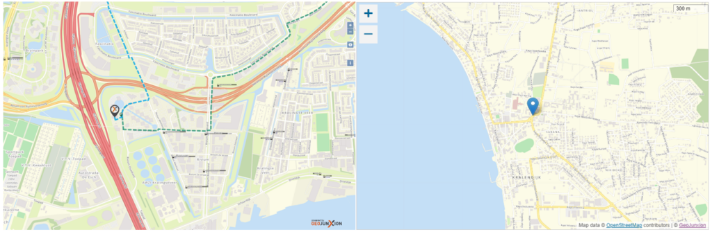
Geocoding for your website or solution is a powerful geo-location tool for transforming a postal address into numerical coordinates, and even validate or correct the address entered. This process is called ‘forward geocoding’, or simply ‘geocoding’. GeoJunxion also offers ‘reverse geocoding’, which converts the numerical coordinates of a specific location into an address, usually the name of a place or a postal address.
Example for geocode point genereated by the GeoJunxion Gecoder
Map Tiles
Effortless Integration, Stunning, Fast, Reliable, Scalable Maps. Elevate your app or website with beautiful, customizable Map Tiles by GeoJunxion. Explore
GeoJunxion offers a Map Tile Server for your website or application with OpenStreetMap Data, GeoJunxion proprietary Map Data or Aerial/Satellite Imagery. The map tiles are generated from the GeoJunxion or OSM map database and are delivered via API request to end-users. We use a combination of methods to make this service very fast and efficient. Furthermore, the map service comes with on-demand tile rendering, smart-tiling and custom styling. With smart tiling, all populated areas are pre-rendered to provide super-fast response to map requests.
Examples of the GeoJunxion Map Tile Server
KEY FEATURES
• 3 databases: GeoJunxion Maps, OSM Maps, Aerial/Satellite Imagery. • 4 custom map styles: GeoJunxion Map Style, OSM Generic/Default, OSM Bright, OSM Bright with house numbers • Map tiles are delivered following the Slippy Maps convention.
TYPICAL USE CASES
The Map Tile Server helps to display business locations on a map within a company website. Moreover, it can show moving objects on a map within a track & trace application. Next, it can also provide an overview of a company assets on a map or include geospatial analysis results within a GIS solution. Some use cases are:
Map Tile Server for your Website
Map Tiles help to display a map or a map with locations on a company website. Further, The Map Tile Server can be used as background maps such as the Outdoor Venue Plan which are turnkey, tailor-made interactive Maps by GeoJunxion.
Map Tile Server for your App
The Map Tile Server will help to display a map in your App for your mobile phone. Read here about the use case for the Map Tile Server by one of our customers.
Map Tile Server for your Solution
The Map Tile Server can easily be integrated into your Solution, both hosted and on-premise. The Map Tile Server will display a map, it shows moving objects within a track & trace application or provides an overview of company’s assets on a map. Furthermore, the Tiles can be used as for include geospatial analysis results within a GIS solution. Read here about the use case for the Map Tile Server by one of our customers.
BENEFITS
OSM Map Tile Server enables you to view online maps within websites or alternatively to view those maps hosted or on-premise through GIS software
COVERAGE
Map: World Aerial/Satellite Imagery: The Netherlands and Flanders (Belgium)
Geoboundaries
As a data and GIS company, we are specialized in curating and developing high-quality geo-boundary datasets. These datasets define the geographic extents of various administrative and natural features, enabling spatial analysis and visualization. Our geo-boundary data is essential for applications ranging from urban planning to environmental management.
The Geo-Boundaries API adds relevant information to a location, based on its numerical co-ordinates – usually the name or type of area.
Get Started Now!
Our experts are always happy to help. Complete the form or contact us to connect with our team and start your journey with GeoJunxion today!